Katima Mulilo and the Eastern Zambezi
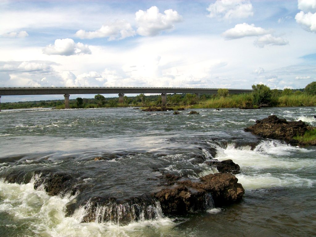
Katima Mulilo sits on the Zambezi River at the far eastern tip of Namibia, well over 1,200 kilometres from Windhoek, closer to Lusaka and Harare than to its own capital. It is the regional capital of the Zambezi Region and the crossing point for Botswana, Zambia and Zimbabwe. Four countries meet within a short distance of it.
The Far End of Namibia
Katima Mulilo’s position is the first thing to understand about it.
The town sits at the eastern extremity of the Caprivi Strip, that narrow finger of Namibian territory reaching east between Angola, Botswana, Zambia and Zimbabwe. The B8 runs the whole way here from Grootfontein, and the total distance from Windhoek is well over 1,200 kilometres, which is two long driving days.
Geographically it belongs to central Africa rather than to the Namibia most visitors know. The Zambezi flows past it, the country is green and wooded, rainfall is several times what the interior receives, and the feel is closer to Zambia than to the desert.
Around 30,000 people live here, making it a substantial regional centre rather than a frontier outpost.
The name is usually translated as quench the fire, referring to rapids on the river.
The Border Crossings
For many travellers Katima Mulilo is a transit point and the crossings are the reason.
Zambia is directly across the Zambezi via the Katima Mulilo bridge, opened in the mid two thousands, which replaced a pontoon and connects to Sesheke on the far bank. From there the road runs north to Livingstone and Victoria Falls.
Botswana lies south, with the crossing at Ngoma leading towards Kasane and Chobe National Park, roughly 100 kilometres away. That is the most used route for travellers combining Namibia with Chobe and the Falls.
Zimbabwe is reachable via Botswana or Zambia, with Victoria Falls a few hours from Kasane.
Cross border travel with a rental vehicle must be declared and authorised in advance, with a letter of authority issued by the rental company. Cross border permits and road fund levies are payable at the border for the vehicle. Insurance terms often change once you leave Namibia.
Arrange all of it at booking rather than at the counter on collection.
Drive the Caprivi Strip one way rather than returning. Katima Mulilo sits within reach of Chobe, Victoria Falls and Livingstone, and turning around to drive 1,200 kilometres back to Windhoek wastes the position entirely. Fly home from Livingstone or Kasane, or arrange a one way vehicle drop, which several Namibian rental companies handle for a fee.
The Zambezi and Impalila Island
The river is what the region runs on and the eastern tip is where it gets interesting.
Impalila Island sits at the extreme eastern point of Namibia, where the Chobe River meets the Zambezi, and from it you can see four countries: Namibia, Botswana, Zambia and Zimbabwe. It is reached by boat rather than by road.
The island holds lodges catering to anglers and birders, and its position gives access to the Chobe frontage without staying in Botswana.
Tiger fishing is the main draw. The Zambezi and Chobe stretches here have a strong reputation, and the fish are fast, aggressive and hard to land. Bream and catfish are the other targets, with catfish reaching substantial size.
Houseboats work the Zambezi and Chobe and operate as floating fishing and birding bases, which is a distinctive way to see this corner.
Hippo and crocodile are everywhere in these waters and are a genuine hazard. Do not swim, stand at the bank or clean fish at the water’s edge.
Wildlife on the Doorstep
Katima Mulilo is the practical base for the eastern Zambezi parks.
Mudumu National Park lies southwest, around 1,000 square kilometres of woodland and floodplain along the Kwando, known for large buffalo herds and holding sable, roan, tsessebe, red lechwe and sitatunga.
Nkasa Rupara, formerly Mamili, sits at the southern tip of the region and is Namibia’s largest protected wetland, with close to a thousand buffalo, the largest concentration in the country, along with the last remnant Namibian population of puku.
Both hold hippo, crocodile, elephant and predators including lion, leopard and African wild dog, and both require four wheel drive.
Elephant move through the whole region in numbers as part of the transfrontier population, with around 12,000 in the Zambezi Region alone, crossing borders that are largely unfenced.
Chobe National Park across the Botswana border holds one of the densest elephant populations in Africa and is within day trip range.
Birding in the Eastern Zambezi
This is the richest birding country in Namibia and Katima Mulilo sits in the middle of it.
The Zambezi Region holds around seventy percent of the country’s bird species, with individual parks recording past 400.
The wetland specials are the draw and occur nowhere else in Namibia: African skimmer, slaty egret, rufous bellied heron, wattled crane, lesser jacana, coppery tailed coucal, greater swamp warbler and Pel’s fishing owl.
Rock pratincole use exposed rock in the channels. Carmine bee eaters nest in colonies in the riverbanks through the warmer months, which is among the more striking sights in this part of Africa.
Migrants arrive from around November and push counts to their annual peak, coinciding with the wet season and its access problems.
Boat based birding is more productive than driving, and most river lodges run cruises that double as birding trips.
The Town Itself
Katima Mulilo is a working regional centre rather than a tourist town.
It has fuel, supermarkets, banks, ATMs, a hospital, government offices and vehicle workshops, making it the last comprehensive service town in this direction and the first if you are arriving from Zambia or Botswana.
The riverfront is where the interest is, with views across the Zambezi and boats working the channel.
The open market sells produce, crafts and woodcarving, and the region has a strong basketry tradition alongside the woodwork of the Kavango further west.
A large baobab in town has a toilet built inside it, which is exactly the sort of detail that makes a small town memorable and is duly signposted.
Accommodation runs to hotels and lodges in town and along the river in both directions, with the riverside properties considerably better than the in town options.
The Caprivi Name and the History
The strip’s shape is the product of a nineteenth century negotiation and the name records it.
It is named after Leo von Caprivi, the German chancellor who negotiated the territory with Britain to give German South West Africa access to the Zambezi and, in theory, a route to the Indian Ocean.
The plan never worked, since Victoria Falls makes the river unnavigable, but the strange shape on the map remained.
The area was renamed the Zambezi Region after independence, though the old name persists in general use and on plenty of signage.
Through the years of the liberation war the strip was a military zone under South African control, which suppressed both settlement and conservation for decades and shapes the region’s development to this day.
The Mafwe, Subiya and Yeyi communities are among those living along the rivers here, with fishing, farming, basketry and woodcarving part of the local economy.

Malaria and Practical Warnings
The eastern Zambezi carries the highest malaria risk in Namibia and this needs stating plainly.
Risk is present year round and peaks during and after the rains, roughly November to May. Chemoprophylaxis is recommended for this area rather than being a matter of judgement.
Travellers arriving from the desert and coast, where no precautions are needed at all, frequently have not considered it, and the change happens over a single long drive.
Alongside medication, cover arms and legs after dusk, use repellent, sleep under a net where provided and keep doors closed at dusk.
The other genuine hazards are hippo and crocodile, both of which kill people in this region annually. Keep away from riverbanks at night and do not swim anywhere in these rivers.
Best Time to Visit
June to October is the window and the reasoning is consistent across the whole region.
Floodwaters recede, roads become passable, game concentrates along the rivers, and malaria risk drops to its annual low. September and October are strongest for wildlife.
January to March is the wet season and it is genuinely disruptive here. Roads flood, some lodges close, sections of Nkasa Rupara become inaccessible and malaria risk peaks. Birding is exceptional, which is the trade birders make.
This is the wettest part of Namibia by a wide margin, so the seasonal swing matters more here than anywhere else in the country.
Getting to Katima Mulilo
The B8 runs east from Grootfontein through Rundu, Divundu and Kongola to Katima Mulilo, tarred the whole way, which makes the main route easier driving than most of Namibia whatever the distance.
Windhoek to Katima Mulilo is well over 1,200 kilometres and two long driving days, with Rundu the natural overnight at around 700 kilometres.
The airport has limited scheduled services, with domestic connections from Eros Airport in Windhoek, which is the alternative to two days of driving.
Kasane in Botswana is roughly 100 kilometres south via the Ngoma border, and Victoria Falls a few hours beyond that.
Katima Mulilo Questions
How far is Katima Mulilo from Windhoek?
Well over 1,200 kilometres, which is two long driving days with Rundu the natural overnight at around 700 kilometres. The B8 is tarred the whole way, making the driving easier than the distance suggests. There are limited scheduled flights from Eros Airport in Windhoek, which is the alternative for anyone unwilling to spend two days on the road.
Can I cross into Botswana or Zambia from here?
Yes, and it is a main reason to come. Zambia is directly across the Zambezi via the Katima Mulilo bridge to Sesheke, with Livingstone and Victoria Falls beyond. Botswana is around 100 kilometres south via the Ngoma crossing towards Kasane and Chobe. Rental vehicles need cross border authorisation arranged at booking, plus permits and levies payable at the border.
Where can I see four countries at once?
Impalila Island, at the extreme eastern tip of Namibia where the Chobe meets the Zambezi, from which Namibia, Botswana, Zambia and Zimbabwe are all visible. It is reached by boat rather than road and holds lodges catering to anglers and birders, with access to the Chobe frontage without staying in Botswana.
Is the fishing good?
Yes, and tiger fish are the draw. The Zambezi and Chobe stretches here have a strong reputation, and the fish are fast, aggressive and notoriously hard to land with a bony mouth that throws hooks. Bream and catfish are the other targets, catfish reaching substantial size. Houseboats work these rivers as floating fishing bases. A permit is required and lodges usually arrange it.
Do I need malaria precautions?
Yes, and unambiguously. The eastern Zambezi carries the highest malaria risk in Namibia, present year round and peaking during and after the rains from November to May. Chemoprophylaxis is recommended rather than being a judgement call. Travellers arriving from the desert, where no precautions are needed, frequently have not considered it and the change happens over one long drive.
Why is it called the Caprivi Strip?
After Leo von Caprivi, the German chancellor who negotiated the territory with Britain to give German South West Africa access to the Zambezi and, in theory, a route to the Indian Ocean. The plan never worked because Victoria Falls makes the river unnavigable, but the shape remained. The area was renamed the Zambezi Region after independence, though the old name persists.
Should I drive back or continue?
Continue if you possibly can. Katima Mulilo sits within reach of Chobe, Victoria Falls and Livingstone, and turning around to drive 1,200 kilometres back to Windhoek wastes the position. Flying home from Livingstone or Kasane, or arranging a one way vehicle drop, which several Namibian rental companies handle for a fee, makes far better use of the distance.
Booking Your Namibia Trip
The safari companies and tour operators listed on this website put trips like this together for a living and know which camps, guides and routes actually deliver. We are an independent guide to Namibia; we do not book or sell tours ourselves.
When you are ready, arrange your safari, tour or holiday with one of the recognised operators listed here. Tell them your dates and what matters most, and a real person, not a form, will handle the itinerary, park bookings and logistics for you.