Namibia National Parks Guide

Namibia’s national parks cover close to a fifth of the country and include the largest park in Africa, an entire protected coastline and a game park with no rivers at all. Around twenty state protected areas sit alongside a network of community conservancies covering a further large share of the land. Entry fees are paid per person per day and were revised upward recently.
How the Namibian Park System Works
Three different kinds of protected land exist here and confusing them causes most of the planning mistakes visitors make.
State run national parks are managed by the Ministry of Environment, with accommodation inside them operated by Namibia Wildlife Resorts. Entry fees are paid at gates or park offices and are valid for a 24 hour period.
Concessions are areas within or adjoining parks leased to private operators, such as Palmwag or the northern Skeleton Coast. Access is only through a lodge booking or licensed operator, and there is no permit an independent traveller can buy.
Community conservancies are communal land where residents hold rights over wildlife and tourism, covering a substantial part of the country. Damaraland and Kaokoland work this way. There is often no gate and no fee, and the wildlife is unfenced and free ranging.
Namibia’s parks are almost all unfenced from each other and from surrounding land, which is why the country’s conservation record is stronger than the park map alone suggests. Between state parks, conservancies and private reserves, something close to 40 percent of Namibia is under some form of conservation management.
Wildlife Parks: Etosha and the Northeast
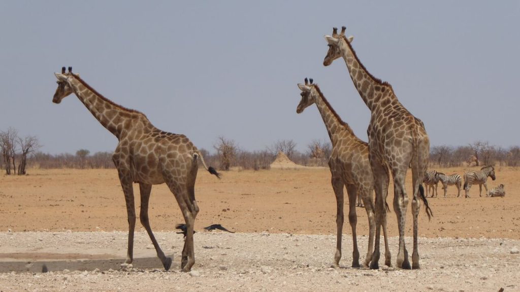
Etosha is the wildlife anchor and the reason most safari visitors come. Around 22,270 square kilometres in the north, built around a salt pan of roughly 4,760 square kilometres, holding 114 recorded mammal species and four of the Big Five. It has no rivers, so through the dry season every animal must come to one of about forty springs and boreholes, which makes game viewing a matter of waiting rather than searching.
In the northeast the character changes completely. Bwabwata spans the Zambezi Region from the Okavango to the Kwando, holding elephant, buffalo, sable, roan and tsessebe. Mudumu along the Kwando is known for buffalo herds. Nkasa Rupara, formerly Mamili, is Namibia’s largest protected wetland with sitatunga and red lechwe in the reed beds.
Khaudum on the Botswana border southwest of the strip is deep sand with no facilities and a firm requirement for two vehicles in convoy. Mangetti in the north is small and rarely visited.
Waterberg Plateau Park in the centre sits on a sandstone massif and holds species relocated there for protection, with walking trails on the plateau and a rest camp below the cliffs.
Desert Parks: Namib-Naukluft and the Sand Sea
Namib-Naukluft is the largest national park in Africa at close to 50,000 square kilometres, and it is really four areas under one name. The southern dune section holds Sossusvlei, Deadvlei and Sesriem. The Naukluft mountains in the east are hiking country reaching towards 2,000 metres. The Namib section inland of Swakopmund is gravel plain with the welwitschia fields and Moon Valley. Sandwich Harbour on the coast is a lagoon reached only by guided 4×4.
Within it, the Namib Sand Sea carries UNESCO World Heritage status, the second Namibian site after Twyfelfontein.
The permit position here catches people out. Sesriem fees are paid at the park office by the gate, but the Welwitschia Drive, Sandwich Harbour and camping in the central Namib all require permits arranged beforehand at Ministry offices in Windhoek or Swakopmund. There is no barrier where you can pay on the way in.
Coastal Parks: Skeleton Coast, Dorob and Tsau Khaeb
Nearly the entire Namibian shoreline is protected, which is unusual anywhere in the world.
Skeleton Coast National Park runs from the Ugab River north to the Kunene. The southern third, between the Ugab and Terrace Bay, is open to permit holding self drivers with strict gate timings. Everything north of Terrace Bay is a high protection wilderness zone open only to fly in guests and concession operators, and there is no permit that lets you drive it.
Dorob National Park picks up from the Ugab and runs about 350 kilometres south to the Kuiseb Delta, covering some 7,800 square kilometres. It was created out of the older West Coast Recreation Area chiefly to control off road driving that was damaging lichen fields and tern breeding grounds. Cape Cross Seal Reserve sits inside it, which surprises visitors who assume Cape Cross is part of the Skeleton Coast.
Tsau Khaeb in the far south is the former Sperrgebiet diamond zone, still largely closed, with guided access only to Bogenfels, Pomona and Elizabeth Bay.

Southern Parks and the Transfrontier Areas
Ai-Ais Richtersveld Transfrontier Park is shared with South Africa and holds Fish River Canyon, a gorge around 160 kilometres long and 550 metres deep. Day visitors use the rim viewpoints from Hobas. Descending into the canyon is limited to permit holding hikers on the multi day trail, which runs only from the start of May to mid September with a minimum party of three and a doctor signed medical certificate.
Ai-Ais at the southern end has thermal springs, chalets and camping, and is the finishing point of the trail.
In the northeast, the Zambezi parks form part of the Kavango Zambezi Transfrontier Conservation Area linking protected land across five countries, which is what allows elephant to follow historic migration routes across largely unfenced borders.
For big game. Etosha above all, then the Zambezi Region parks for buffalo, hippo and crocodile, which Etosha lacks entirely.
For scenery. Namib-Naukluft for the dune sea, Ai-Ais Richtersveld for Fish River Canyon, and Skeleton Coast for austerity and fog.
For hiking. The Naukluft mountains, the Fish River Canyon trail and Waterberg Plateau. All require permits and most have seasonal restrictions.
For solitude. Khaudum, Mangetti, western Etosha and the northern Skeleton Coast. All demand more preparation than the headline parks.
Park Fees, Permits and Booking
Fees are charged per person per day with a separate vehicle charge, and they run for a 24 hour period from entry. The national schedule was revised upward recently, and this is where most published figures are now wrong.
Older sources widely quote around 150 Namibian dollars per international adult at the major parks and 80 or less at smaller ones. The current position sits materially higher, likely in the region of 200 to 280 Namibian dollars per international adult at parks like Etosha and Namib-Naukluft, made up of an entrance portion and a conservation levy of roughly equal size. Vehicles with ten seats or fewer are charged around 60 Namibian dollars. SADC nationals and Namibian residents pay substantially less, and young children enter free.
Namibia Wildlife Resorts does not publish figures clearly on its own pages, linking to a downloadable schedule instead, which is why the confusion persists. Confirm at the gate rather than budgeting from anything online, including this.
Accommodation inside the parks is booked through Namibia Wildlife Resorts, and the Etosha camps and Sesriem sell out six to nine months ahead for the dry season.
Park Rules Every Visitor Should Know
A handful of rules apply across the system and breaching them carries real penalties.
Gates open at sunrise and close at sunset, with times moving week to week. Driving after dark inside a park is prohibited outright and fines are heavy. You must stay in your vehicle except at designated points, and photo identification is required at entry gates.
Driving off marked roads is prohibited, which matters most on the coast and gravel plains where lichen fields take decades to recover from a single set of tyre tracks. Wild camping is not permitted in national parks, only at designated sites. Drones require authorisation that is not available to ordinary visitors at most sites.
Community Conservancies Alongside the Parks
The conservancy network is the part of Namibian conservation that the park map does not show, and it is the more interesting story.
Communal conservancies give residents rights over wildlife and tourism income on their own land. The model developed in Damaraland has driven the strongest community led wildlife recovery in Africa: black rhino in the northwest have grown from under thirty animals to around two hundred, and elephant numbers across the wider northwest have recovered substantially from their low point.
Practically this means much of the best wildlife country in Namibia sits outside the parks entirely. Palmwag, Torra, Nyae Nyae, the Kunene conservancies and the Damaraland areas are all conservancy land, usually with lodges operating as joint ventures.
Best Time to Visit Namibia’s Parks
May to October is the dry season and the working window across most of the system, with July through September strongest for wildlife. Water disappears, animals concentrate at permanent springs, and grass cover thins.
Seasonal closures matter in a few places. The Fish River Canyon hiking trail runs only from May to mid September. Torra Bay campsite on the Skeleton Coast opens only in December and January. The Zambezi parks flood between January and March, with some lodges closing and malaria risk peaking.
Green season from November to April disperses game and improves birding sharply, with lower rates and far fewer visitors throughout.
Getting to Namibia’s National Parks
Most trips start at Hosea Kutako International Airport outside Windhoek. Etosha is four and a half to five and a half hours north on tar. Sesriem is about five hours southwest, mostly gravel. The coast is four hours west on tar. Fish River Canyon is six to seven hours south.
An ordinary car reaches the main parks in the dry season. A 4×4 is needed for the sandy stretch at Sossusvlei, Khaudum, the Naukluft 4×4 route and most conservancy tracks.
Entry rules to the country changed recently: Namibia withdrew visa free entry for many European, North American and Australasian passports, so travellers from those countries now need a visa on arrival or a holiday visa arranged online in advance.
Namibia National Parks Questions
How much do Namibia’s national park fees cost?
Fees are per person per day plus a vehicle charge, valid for 24 hours from entry. The schedule was revised upward recently and most published figures are out of date. Older sources say around 150 Namibian dollars per international adult at major parks, while the current rate likely sits in the 200 to 280 range once the conservation levy is counted, with smaller parks lower. Vehicles under ten seats are around 60. SADC and Namibian residents pay considerably less. Confirm at the gate.
How many national parks does Namibia have?
Around twenty state protected areas, ranging from Namib-Naukluft at close to 50,000 square kilometres, the largest in Africa, down to small parks that see almost no visitors. Alongside them sits an extensive network of communal conservancies, and between the two something close to 40 percent of the country is under some form of conservation management, which is among the highest proportions anywhere.
Which Namibian park is best for wildlife?
Etosha, comfortably, because the absence of rivers forces every animal to a small number of waterholes through the dry season. It holds four of the Big Five and 114 mammal species. The Zambezi Region parks in the northeast are the only place in Namibia with buffalo, hippo and crocodile. For free roaming black rhino and desert adapted elephant, the conservancy land in Damaraland outperforms any national park.
Do I need permits in advance for Namibian parks?
For most, no, since fees are paid at the gate. The exceptions matter though. The Welwitschia Drive, Sandwich Harbour and camping in the central Namib all need permits arranged beforehand at Ministry offices in Windhoek or Swakopmund. The Fish River Canyon hiking trail needs a permit booked months ahead with a medical certificate. Concession areas cannot be accessed by permit at all, only through a lodge or licensed operator.
Can I camp anywhere in Namibian national parks?
No. Wild camping is prohibited throughout the park system and camping is only permitted at designated sites. This protects lichen fields and desert crust that take decades to recover from vehicle tracks, particularly on the coast. Designated sites are well distributed and mostly well run, so it rarely constrains a planned route.
Are Namibia’s parks fenced?
Mostly not, which is central to how conservation works here. Wildlife moves between parks, conservancy land and private reserves, and in the northeast across international borders as part of a transfrontier conservation area spanning five countries. Etosha is the notable exception, being fenced, which is partly why buffalo can be excluded from it on veterinary grounds.
Which parks need a 4×4?
The main circuit through Etosha, Namib-Naukluft’s tar section and Waterberg is manageable in an ordinary car during the dry season. You need genuine four wheel drive for the final five kilometres to the Sossusvlei pans, the Naukluft 4×4 route, Sandwich Harbour, the Zambezi park tracks and Khaudum, which also requires two vehicles travelling in convoy with full recovery equipment.
Booking Your Namibia Trip
The safari companies and tour operators listed on this website put trips like this together for a living and know which camps, guides and routes actually deliver. We are an independent guide to Namibia; we do not book or sell tours ourselves.
When you are ready, arrange your safari, tour or holiday with one of the recognised operators listed here. Tell them your dates and what matters most, and a real person, not a form, will handle the itinerary, park bookings and logistics for you.