Ruacana Falls
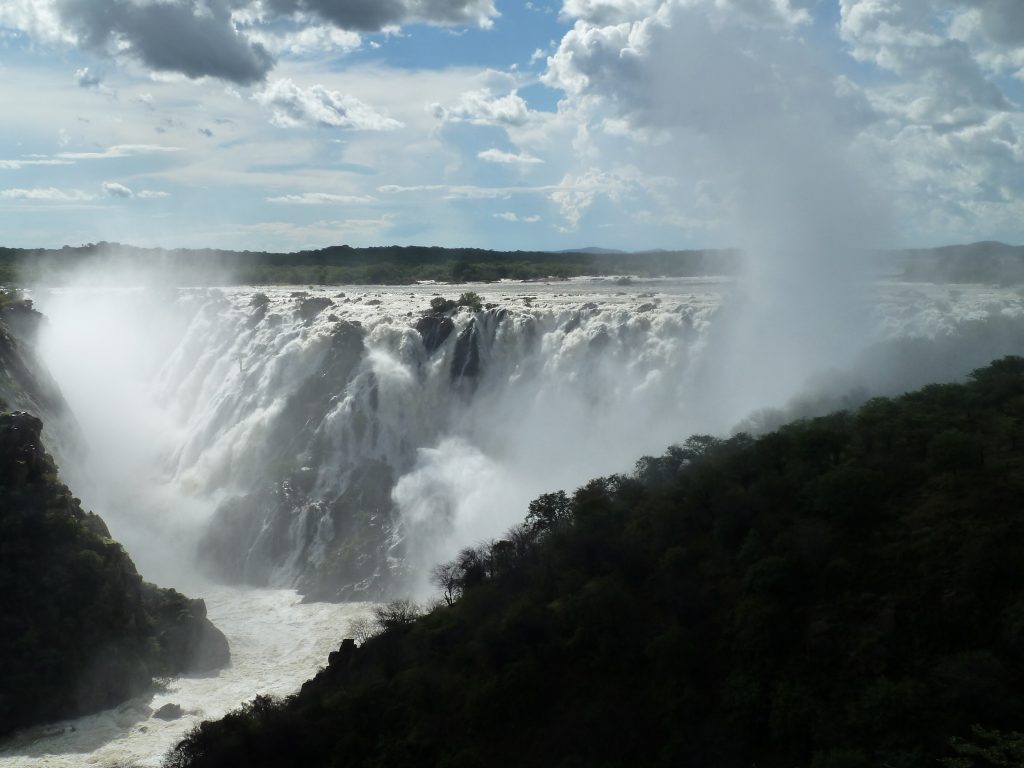
Ruacana is Namibia’s largest waterfall and it is dry most of the year. At 107 metres high and up to 700 metres wide in flood it ranks among Africa’s largest by volume and width. A hydroelectric station above it diverts the water for most of the year. March and April are when it runs, and even then only after heavy rain.
Why It Usually Is Not There
This needs stating first, because travellers drive a long way to find a dry cliff.
The Ruacana Hydroelectric Power Station sits directly above the falls and uses most of the water for electricity generation through the greater part of the year.
Flow is regulated upstream by the Calueque Dam in Angola, about 40 kilometres away. A diversion weir above the falls feeds an eight metre wide underground pressure tunnel running 1,500 metres from the Angolan side to the power station.
During the dry season the river is siphoned off entirely and the falls run dry.
From roughly December to June, monsoon rains in the catchment provide enough water that the hydro scheme reaches capacity and the surplus goes over the falls in their natural state.
March and April are the best months to see water crashing over the rock, and even then it requires consistent heavy rain rather than a normal season.
Phone ahead before driving to Ruacana just for the falls. Lodges in the area know whether water is coming over and it changes week to week with rainfall and generation demand. There is a further quirk: flow increases with electricity demand on weekday mornings and evenings, and it takes several hours to travel downstream, so even the daily picture shifts. A dry cliff after a five hour drive is a poor outcome that one call prevents.
What It Is When It Runs
In full flood it justifies the reputation entirely.
The Kunene drops 107 metres over a broad semi-crescent scarp into a narrow gorge on the Angolan border. At peak discharge the falls can stretch over a kilometre wide, with 700 metres a commonly cited figure in flood.
That places it among the largest waterfalls in Africa by both volume and width when it is running.
The name comes from an Otjiherero phrase meaning the hurrying of the water, which is apt for the months it lives up to.
The falls straddle the border, with the primary viewpoints on the Namibian side, which is why they are usually listed as Namibian.
The gorge below is dramatic in any season, and the setting where the Owamboland plains meet the mountains of Kaokoland is worth the drive on its own terms.
Ruacana Compared to Epupa
The two Kunene waterfalls are frequently confused and they are quite different propositions.
Ruacana is larger by a considerable margin when it runs, at 107 metres against Epupa‘s main drop of around 37, and vastly wider in flood.
Epupa runs year round with varying volume, since no scheme controls it. Ruacana is heavily controlled and can be a dry cliff for months.
Epupa is a series of channels across a front around a kilometre and a half wide, framed by makalani palms and baobabs, which photographs better in most conditions. Ruacana is a single scarp into a gorge.
Epupa has camps on the riverbank and is a destination in itself. Ruacana is more often a stop.
The practical advice is that Epupa is the dependable one and Ruacana is the spectacular one in the right month. Travellers with time for one should choose Epupa unless it is March or April after heavy rain.
Getting There and the Viewpoints
Access is straightforward compared with most of Kaokoland.
The falls sit around 15 to 25 kilometres west of Ruacana town, well signposted from the C46, with the D3700 running towards them.
Around 12 kilometres from town there is a pull off where a short walk leads to a lookout giving an elevated view of the weir and the falls to its left.
The main viewpoint sits close to the border crossing into Angola.
The drive out passes cattle and goats, shebeens and an open air market beside the road, which is a fair introduction to the region.
Roads to the viewpoints are manageable in an ordinary vehicle, which distinguishes Ruacana from most of the northwest.
Ruacana Town
The town exists because of the power station and it shows.
It was built during construction of the hydroelectric scheme and retains the character of a purpose built settlement rather than an organic one.
It sits at the meeting point of the Owamboland plains and the mountains of Kaokoland, which makes the surrounding country unusually varied, with rock formations, savanna and desert terrain within a short distance.
The town has fuel, basic supplies and guesthouse accommodation, which makes it a useful staging point.
It is around 25 kilometres east of the falls themselves.
The welcome sign, with letters long since broken off and a headless statue beside it, is the detail visitors remember, and it sets expectations about the town accurately.

The Kunene Beyond the Falls
The river remains the reason to be here even when the falls are dry.
The Kunene continues to flow below the scheme, supporting riverside lodges with gardens and shade in country that is otherwise severe.
White water rafting and canoeing operate on this stretch and are among the better activities in the northwest.
Birdlife along the river is strong, and the riverine vegetation supports species absent from the surrounding country.
Crocodiles are present in the Kunene and the usual rules apply: no swimming, no standing at the water’s edge, no cleaning fish at the bank.
Himba communities live throughout this region, and visits should be arranged through local guides who know the families rather than by arriving unannounced.
The Hydro Scheme Itself
The power station is the reason the falls behave as they do and it is a substantial piece of infrastructure in its own right.
Ruacana is Namibia’s largest power generating facility and supplies a considerable share of the country’s electricity, which is why the water goes through turbines rather than over rock for most of the year.
The arrangement is unusual in that the station sits on the Namibian side while the water is regulated from the Angolan side, at the Calueque Dam roughly 40 kilometres upstream.
That makes generation dependent on a bilateral relationship, and the Kunene is governed by a joint commission between the two countries.
The underground pressure tunnel running 1,500 metres from the Angolan side to the surge head bay is the engineering centrepiece, and the station itself is largely built into the rock rather than standing above ground.
Understanding this explains the daily variation in flow, since generation rises with electricity demand on weekday mornings and evenings and the water takes hours to reach downstream points.
It also explains why the falls will not return to their historical state: the scheme is permanent, and the dry cliff is now the normal condition rather than a temporary one.
Where It Fits in a Route
From Etosha. Ruacana sits north of the park, reachable via Oshakati and Outapi, which makes it an addition to a northern route rather than a detour into Kaokoland.
To Opuwo. The C41 and C35 connect Ruacana south to Opuwo, from which Epupa is 180 kilometres north on the C43. Doing both falls is a natural pairing.
The Kunene loop. Ruacana, Opuwo, Epupa and back south through Sesfontein and Palmwag makes a substantial northwestern circuit of a week or more.
As a stop. For most travellers Ruacana is a half day rather than a destination, particularly outside the flood months.
Best Time to Visit
March and April, and the qualification matters more than the months.
The falls run from roughly December to June when monsoon rains fill the catchment beyond what the hydro scheme can use, with March and April the peak.
Even then, spectacular flow requires consistent heavy rain rather than an average season, so a poor rainfall year may produce little.
From July to November the river is siphoned off and the falls are usually dry.
Flow also varies daily, increasing with electricity demand on weekday mornings and evenings, and taking several hours to travel downstream.
The trade off is that the flood months are also the wet season in the north, when roads deteriorate and malaria risk is highest, so timing for the falls means accepting worse conditions elsewhere.
Ruacana Falls Questions
Are Ruacana Falls worth visiting?
In March or April after heavy rain, absolutely, since at 107 metres high and up to 700 metres wide in flood it ranks among Africa’s largest by volume and width. Outside those months the river is siphoned off for hydroelectric generation and the falls are usually dry. Phone ahead before driving there just for the falls, since lodges know whether water is coming over.
Why are the falls often dry?
The Ruacana Hydroelectric Power Station sits directly above them and uses most of the water for most of the year. Flow is regulated by the Calueque Dam about 40 kilometres upstream in Angola, and a diversion weir feeds an eight metre wide underground pressure tunnel running 1,500 metres to the station. During the dry season the river is siphoned off entirely.
When do they run?
Roughly December to June, when monsoon rains fill the catchment beyond what the hydro scheme can use, with March and April the best months. Even then, spectacular flow needs consistent heavy rain rather than an average season. Flow also varies daily, increasing with electricity demand on weekday mornings and evenings and taking several hours to travel downstream.
How do Ruacana and Epupa compare?
Ruacana is far larger when it runs, at 107 metres against Epupa’s main drop of around 37, and vastly wider in flood. Epupa runs year round with varying volume since nothing controls it, and is framed by makalani palms and baobabs across a front a kilometre and a half wide. Epupa is the dependable one; Ruacana is the spectacular one in the right month.
How do I get there?
The falls sit around 15 to 25 kilometres west of Ruacana town, signposted from the C46 with the D3700 running towards them. A pull off about 12 kilometres from town gives an elevated lookout over the weir and falls, and the main viewpoint sits close to the Angolan border crossing. Roads are manageable in an ordinary vehicle, unlike most of Kaokoland.
Is there anything else to do there?
Yes, and it is why the area is worth a stop even when the falls are dry. The Kunene continues to flow below the scheme, supporting riverside lodges, white water rafting and canoeing, and strong birdlife along the riverine vegetation. Crocodiles are present, so no swimming or standing at the water’s edge. Himba communities live throughout the region.
Where does Ruacana fit in a trip?
North of Etosha, reachable via Oshakati and Outapi, which makes it an addition to a northern route rather than a detour into Kaokoland. The C41 and C35 connect it south to Opuwo, from which Epupa is 180 kilometres north, making a Ruacana and Epupa pairing natural. For most travellers it is a half day rather than a destination.
Booking Your Namibia Trip
The safari companies and tour operators listed on this website put trips like this together for a living and know which camps, guides and routes actually deliver. We are an independent guide to Namibia; we do not book or sell tours ourselves.
When you are ready, arrange your safari, tour or holiday with one of the recognised operators listed here. Tell them your dates and what matters most, and a real person, not a form, will handle the itinerary, park bookings and logistics for you.