Erongo Mountains

The Erongo Mountains are the eroded remains of a volcano that collapsed in on itself, standing between Omaruru and Usakos in central Namibia. What is left is a granite massif holding one of the richest concentrations of San rock art in the country, including the White Elephant at Phillip’s Cave. A conservancy of 30 private landowners covers around 2,000 square kilometres of it.
The Remains of a Volcano
The Erongo is not a mountain range in the usual sense. It is what is left after a volcano.
Between roughly 110 and 130 million years ago, massive volcanic activity in this area produced enormous quantities of magma that cooled below the surface into granite. The volcano itself eventually collapsed, and over an extremely long period the softer surrounding rock eroded away, leaving the hard granite core standing.
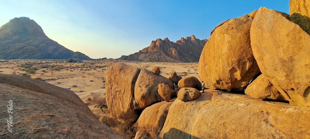
What you see now is that core: a broad massif of granite rising from the plain, with boulder fields, domed hills and rock faces spreading out from it.
The weathering that produced the shapes is worth a moment, because it explains why the boulders look the way they do. Granite is hard but porous, and it cracked into blocks along joints while still underground. Once exposed, water worked those joints and the corners weathered faster than the flat faces, rounding each block into a boulder in a process called spheroidal weathering.
Temperature does the rest. Swings here are extreme enough that a sudden rain shower on a very hot day can split a boulder with an audible bang, which local geologists describe as radial cracking.
Phillip’s Cave and the White Elephant
The rock art here is the reason the Erongo mattered to archaeology before Brandberg did.
Phillip’s Cave sits on the farm Ameib on the southern edge of the massif, a shelter around 35 metres long, 15 metres deep and seven metres high. Stone tools found in it have been dated to around 3500 BC, which supports the reading that San communities lived here rather than only visiting.
The famous image is the White Elephant, a large white figure with a red antelope superimposed across it, and it is among the better known rock paintings in southern Africa. The cave is a national monument.
It was brought to international attention by Abbé Breuil, the French prehistorian, who published a book on the site. Breuil is the same figure who named the White Lady at Brandberg after comparing it to Cretan Greek art, an interpretation since discarded, so his work here comes with the same caveat about early European readings of San art.
Before the Brandberg paintings became widely known, Phillip’s Cave was arguably the most important rock art site in the territory.
The Erongo holds water when almost nothing around it does. Impermeable granite pans fill during the rains and hold through the dry winter, which is exactly why San communities lived here and why wildlife concentrates in the massif. Knowing that changes how the rock art reads: this was not a place people passed through, it was a place they could stay.
Bull’s Party and Elephant’s Head
The granite formations at Ameib are the other draw and they are among the better photographic subjects in Namibia.
Bull’s Party is a cluster of enormous rounded boulders leaning together in a way that suggests a group of cattle standing in conference, which is where the name comes from. Elephant’s Head is a separate formation nearby, a granite dome that looks convincingly like the animal.
Both are reached almost directly by vehicle on a track of about five kilometres from Ameib, or on foot from the guesthouse. A short loop links Bull’s Party, Elephant’s Head and Phillip’s Cave, recorded by walkers at around three and a half kilometres with roughly 190 metres of ascent.
Another much photographed formation nearby resembles a Herero woman in traditional dress standing with two children.
Early morning and late afternoon are the times to be there. The soft light on granite is what makes these images work, and at midday the whole field flattens out.
For experienced climbers there is a via ferrata style route around and up Elephant’s Head, starting at rock paintings at the foot and finishing with a view across the massif.
The Erongo Mountain Nature Conservancy
The conservation arrangement here is unusual and it is why the area works as a destination.
Around 30 private landowners have combined their properties into a conservancy covering roughly 2,000 square kilometres, managed jointly for conservation rather than as separate farms. Fences have come down between them and wildlife moves across the whole area.
That has produced a protected area larger than several national parks, entirely on private land, at no cost to the state. It is the freehold equivalent of the communal conservancy model that transformed Damaraland.
Rhino have been reintroduced to parts of the massif under a dedicated trust, and the area supports rare and endemic plants and animals alongside the general game.
Practically, it means the lodges you stay at are conservancy members and your bed night funds the arrangement.
Wildlife and Birding in the Erongo
The Erongo is not a big game destination and the birding is genuinely strong.
Between 200 and 260 bird species have been recorded across the massif, and it is one of the better places in Namibia for the near-endemics. Hartlaub’s spurfowl works the granite, the rockrunner sings from the boulders early in the morning, and Carp’s tit, Rüppell’s parrot, Monteiro’s hornbill and the white tailed shrike all occur in the surrounding woodland.
Mammals include Hartmann’s mountain zebra on the rocky ground, kudu, oryx, springbok, klipspringer, steenbok, giraffe and warthog, with leopard present and rarely seen. Baboon and dassie work the granite.
The rock itself supports a specialised set of reptiles: rock agamas turning blue and orange in breeding condition, girdled lizards, and geckos including Koch’s barking gecko, whose call carries across the plains at dusk.
Where to Stay in the Erongo
Accommodation clusters around the massif and most properties sit within the conservancy.
Ameib is the historic one, a working property whose name means green place and which began as a Rhenish mission station in 1864. It offers guest rooms and camping and holds both Phillip’s Cave and Bull’s Party, with walking trails from the guesthouse.
Ai Aiba, west of Omaruru, is built among granite boulders and organised around rock art, with guided walks to painting sites and open vehicle drives. The Erongo Wild is a founder member of the conservancy. Erongo Plateau Camp offers private campsites in the heart of the range.
Etusis, near Karibib, sits in a 22,000 hectare private conservation area in the marble mountains, roughly halfway between Windhoek and Swakopmund.
Fitting the Erongo Into a Route
The massif sits between Windhoek and Swakopmund and slightly north, which makes it the natural first or last night of a Namibian trip.
Ameib is around 30 kilometres from Usakos and 240 kilometres from Windhoek, close enough to the capital for an arrival night and far enough to feel like the trip has started. Omaruru is the other access point.
Spitzkoppe lies west and is often paired with the Erongo, since both are granite and both offer rock art and camping. The two are different enough to justify doing both: Spitzkoppe is a dramatic isolated cluster, the Erongo a broad massif you move around inside.
Travellers heading north to Damaraland and Etosha pass this way, as do those going west to the coast.
Best Time to Visit the Erongo
May to September is the walking season. Cooler temperatures make the granite trails workable, and this is when the mountains hold their water in the rock pans while the surrounding country dries out.
Summer heat on bare granite is serious. There is little shade, the rock radiates heat well into the evening, and even short walks become hard work between October and March. Early starts are the only way in those months.
Smooth granite becomes genuinely hazardous when wet, so take care after rain. Closed shoes, generous water, sun protection and early starts are standard requirements here rather than optional advice.
Getting to the Erongo Mountains
The massif lies between Omaruru and Usakos in central Namibia, reached from the B2 between Windhoek and Swakopmund or from the C33 running north to Omaruru.
Ameib sits around 30 kilometres from Usakos, with Phillip’s Cave about three kilometres off the farm road and a walk of around 45 minutes each way to reach the painting. Lodges west of Omaruru are 50 to 60 kilometres out on gravel.
Access roads are gravel and manageable in an ordinary car in dry conditions, though higher clearance is more comfortable. Most walks start from lodges or private farms, and rock art visits and the higher granite routes require a guide.
Erongo Mountains Questions
What are the Erongo Mountains?
The eroded remains of a volcano. Massive volcanic activity between roughly 110 and 130 million years ago produced magma that cooled underground into granite. The volcano later collapsed and the softer surrounding rock eroded away, leaving the hard granite core standing as the massif you see today, with its boulder fields and domed hills.
What is the White Elephant?
A large white painted figure in Phillip’s Cave on the farm Ameib, with a red antelope superimposed across it, and among the better known rock paintings in southern Africa. The cave is a national monument, around 35 metres long and seven high, and stone tools found there date to about 3500 BC. It was brought to international attention by the French prehistorian Abbé Breuil.
What is Bull’s Party?
A cluster of enormous rounded granite boulders at Ameib leaning together in a way that suggests cattle standing in conference. Nearby is Elephant’s Head, a granite dome that looks convincingly like the animal. Both are reached by a five kilometre track from Ameib or on foot, and both work best in the soft light of early morning or late afternoon.
Why is there so much rock art in the Erongo?
Because the mountains hold water when the surrounding country does not. Impermeable granite pans fill during the rains and retain water through the dry winter, which supported both wildlife and the San communities who lived here in caves and crevices. This was a place people could stay rather than pass through, which is why the concentration of paintings is so high.
What is the Erongo Mountain Nature Conservancy?
An arrangement in which around 30 private landowners combined their properties into a single conservation area of roughly 2,000 square kilometres, taking down fences between them so wildlife moves freely. It is larger than several Namibian national parks, entirely on private land, and it is the freehold equivalent of the communal conservancy model used in Damaraland.
Is the Erongo good for birding?
Yes, and it is one of the better places in Namibia for the near-endemics. Between 200 and 260 species have been recorded. Hartlaub’s spurfowl works the granite, the rockrunner sings from boulders early in the morning, and Carp’s tit, Rüppell’s parrot, Monteiro’s hornbill and the white tailed shrike all occur in the surrounding woodland.
How does the Erongo compare to Spitzkoppe?
Both are granite with rock art and camping, and they are different enough to justify doing both. Spitzkoppe is a dramatic isolated cluster rising abruptly from flat plain, best known for its rock arch and its camping among boulders. The Erongo is a broad massif you move around inside, with a wider spread of rock art, better birding and a network of lodges and farms.
Booking Your Namibia Trip
The safari companies and tour operators listed on this website put trips like this together for a living and know which camps, guides and routes actually deliver. We are an independent guide to Namibia; we do not book or sell tours ourselves.
When you are ready, arrange your safari, tour or holiday with one of the recognised operators listed here. Tell them your dates and what matters most, and a real person, not a form, will handle the itinerary, park bookings and logistics for you.