Vingerklip
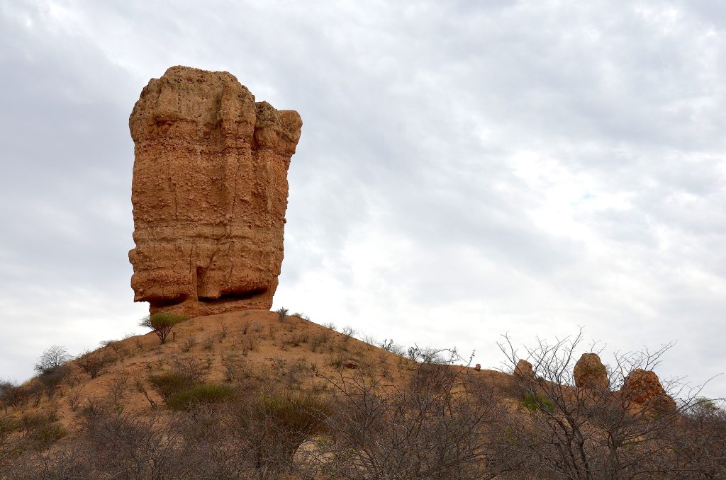
Vingerklip is a 35 metre rock pillar standing on a hilltop above the Ugab Terraces in Damaraland, and since the collapse of the Finger of God in the south it has been the most famous rock formation in Namibia. It is an erosion remnant of a terrace the Ugab River cut away around it. The surrounding country resembles Monument Valley more than Africa.
The Rock Finger and Its Dimensions
Vingerklip is Afrikaans for rock finger and the name is accurate rather than poetic.
The pillar stands about 35 metres high and roughly 15 metres wide, with a base circumference of around 44 metres, and its tip sits 929 metres above sea level. Seen from close up the surface is dotted with protruding stones, which gives it the look of a climbing wall.
That broad, sound base is why it is still standing. Vingerklip sits on a substantial foundation rather than a narrow neck, and in country that receives very little rain, erosion is slow enough that it should remain for a long time yet.
The comparison is with Mukurob, the Finger of God in southern Namibia, which stood on a far narrower base and collapsed in December 1988. Vingerklip inherited the title of Namibia’s best known rock formation by outlasting it.
How the Ugab River Made It
The geology here reads clearly enough that guides describe it as an open book, and it is worth a few minutes before you photograph the thing.
Vingerklip is built from layers of sedimentary rock dating to the Tertiary period, predominantly carbonated sandstones and conglomerates laid down by the forerunners of the Ugab river system.
Those deposits once formed a continuous layer across this country. The Ugab then cut down through it, and because the speed and volume of the water fluctuated over an enormous span of time, it carved the land into a series of terraces rather than a single valley.
Three terrace levels can be distinguished around the site. The oldest and highest plateau now stands around 160 metres above the current riverbed, a younger terrace sits about 100 metres up, and the youngest around 30 metres.
Vingerklip is what is left of one of those terraces after the rest eroded away, a witness to a layer that has otherwise gone. The larger flat topped hills scattered around it are the same thing on a bigger scale.
Do not stop at the roadside viewpoint and drive on. Walk up the hill to the base of the pillar, which takes around twenty minutes and puts the scale in proportion, and then look outward rather than upward. The Ugab Terraces spread out around you in a way that no photograph of the rock itself conveys, and it is the terraces rather than the finger that people remember.
Climbing History
Vingerklip has been climbed twice in ways worth recording, and it should not be climbed now.
The first ascent is credited to the American mountaineer Tom Choate, who reached the top in 1970 and left hooks that are still visible on the rock.
Three years later Udo Kleyenstuber climbed it free, ascending the east side without aid, which given the crumbly conglomerate surface was a considerable piece of work.
Climbing the pillar is now prohibited. Visitors may walk up the hill on which it stands and reach the base, and that is as far as it goes. The rock is sedimentary and friable, and the protection reflects both the fragility of the formation and the obvious hazard.
The Ugab Terraces
The terraces are the reason to make the detour and the pillar is the excuse.
Driving in from the C39, the view opens across a broad valley of table mountains and layered plateaus stretching to the horizon. The comparison people reach for is Arizona, and it is a fair one: flat topped mesas, stepped sedimentary layers and enormous space.
The Ugab River that cut all this is now seasonal, running only after good rain. It rises in the western foothills of the Otavi Mountains, passes south of Outjo and north of Brandberg, and eventually reaches the Atlantic at the Ugab gate of Skeleton Coast National Park.
Several walking trails run through the terraces from the lodge in the area, ranging from about one to three hours, and they show the country properly in a way no car park view does.
Where to Stay at Vingerklip
Vingerklip Lodge sits at the foot of one of the terraces with the pillar in view, built from local stone and thatch, with chalets facing the valley, two pools and a restaurant.
Its Eagles Nest restaurant sits high on a terrace above the lodge, reached by a walkway and a metal staircase, and dinner up there with the valley below is what most guests single out.
A suite on top of the terraces is reached by the same short mountain walkway followed by a 25 metre climb up a metal staircase, which is worth knowing about if anyone in your party has difficulty with heights or walking.
Ugab Terrace Lodge is the other property in the area, and Damara Mopane Lodge near Khorixas serves the wider circuit. Day visitors are usually welcome at the lodges for lunch, though phoning ahead is sensible.

Fitting Vingerklip Into a Route
Vingerklip sits roughly halfway between Etosha and Swakopmund, which makes it a natural break rather than a detour for anyone driving that leg.
From the central Damaraland circuit it is within day trip range of Twyfelfontein, the Organ Pipes, Burnt Mountain, the Petrified Forest and Brandberg with the White Lady. A night here covers the eastern end of that circuit comfortably.
Many travellers pass it without knowing, since staying on the tar road means missing it entirely. The turning is signposted and the detour is short.
Mukurob and the Rock That Fell Over
Vingerklip’s status rests partly on the fate of another Namibian rock, and the story is worth knowing.
Mukurob, known in English as the Finger of God, stood in southern Namibia and was for decades the country’s best known natural landmark. It was a tall pillar of sandstone resting on a comparatively narrow neck of softer shale, and it appeared on postcards, stamps and tourist literature throughout the region.
In December 1988 it collapsed. The neck had been weathering for a very long time and finally gave way, leaving a heap of rubble where the formation had stood. Debate followed about whether an earthquake in Armenia days earlier had contributed, though erosion alone was sufficient explanation.
Vingerklip inherited the title by virtue of a broad and sound base. Where Mukurob balanced on a narrow support, Vingerklip sits on a foundation of roughly 44 metres circumference in country receiving very little rain.
It is a useful reminder that these formations are temporary on a geological timescale. The Ugab Terraces were once a continuous layer, Vingerklip is what remains of one part of it, and in time it will go the same way as the rest.
Best Time to Visit Vingerklip
The formation looks the same year round, so timing is about light and comfort rather than season.
Late afternoon is the window. Low sun brings out the layering in the conglomerate and throws the terraces into relief, and sunset from the higher ground is what the lodges are built around. Sunrise works from the other direction.
May to September gives comfortable walking temperatures for the trails through the terraces. Summer from October to March is hot enough that walking should be confined to early morning.
Getting to Vingerklip
Vingerklip lies roughly 50 kilometres east of Khorixas and around 80 kilometres southwest of Outjo. Driving the C39 from Outjo towards Khorixas, turn onto the D2743 after about 70 kilometres, following the Vingerklip sign.
After a few kilometres the road reaches the Ugab and the view opens across the terraces, which is the moment the detour justifies itself.
The roads are gravel and manageable in an ordinary car in dry conditions, with higher clearance more comfortable. A modest entry fee is charged at the site.
Vingerklip Questions
How tall is Vingerklip?
About 35 metres high and roughly 15 metres wide, with a base circumference of around 44 metres, and its tip 929 metres above sea level. It stands on a hilltop above the Ugab Terraces, so the apparent height from the valley floor is considerably greater than the pillar itself.
What is Vingerklip made of?
Layers of sedimentary rock from the Tertiary period, predominantly carbonated sandstones and conglomerates laid down by the forerunners of the Ugab river system. It is an erosion remnant: the river cut down through a continuous layer that once covered this country, leaving the pillar and the surrounding table mountains as witnesses to what has gone.
Can I climb Vingerklip?
No, climbing the pillar is prohibited. Visitors may walk up the hill on which it stands and reach the base, which takes around twenty minutes and is worth doing. The rock was first climbed in 1970 by American mountaineer Tom Choate, whose hooks are still visible, and climbed free in 1973 by Udo Kleyenstuber, but it is now protected.
Why is Vingerklip Namibia’s most famous rock?
Because the previous holder of the title fell over. Mukurob, the Finger of God in southern Namibia, stood on a far narrower base and collapsed in December 1988. Vingerklip sits on a broad, sound base of around 44 metres circumference in country with very little rainfall, so erosion is slow and it should stand for a long time yet.
What are the Ugab Terraces?
A valley of layered table mountains and stepped plateaus cut by the Ugab River over an enormous span. Three terrace levels can be distinguished, the oldest standing around 160 metres above the current riverbed, a younger one about 100 metres and the youngest around 30. The country resembles Monument Valley in Arizona more than most people expect of Africa.
Is Vingerklip worth the detour?
Yes, though for the terraces rather than the pillar. Visitors who come for a single rock and photograph it from the car park are frequently underwhelmed. Those who walk up to the base and then look outward across the valley of table mountains mostly rate it among the better stops in Damaraland. Several walking trails of one to three hours run through the terraces.
Where does Vingerklip fit on a Namibian route?
Roughly halfway between Etosha and Swakopmund, which makes it a natural break on that drive rather than a detour. It sits within day trip range of Twyfelfontein, the Organ Pipes, Burnt Mountain, the Petrified Forest and Brandberg. Staying on the tar road means missing it entirely, which is what most travellers do.
Booking Your Namibia Trip
The safari companies and tour operators listed on this website put trips like this together for a living and know which camps, guides and routes actually deliver. We are an independent guide to Namibia; we do not book or sell tours ourselves.
When you are ready, arrange your safari, tour or holiday with one of the recognised operators listed here. Tell them your dates and what matters most, and a real person, not a form, will handle the itinerary, park bookings and logistics for you.