Namibia’s Atlantic Coast
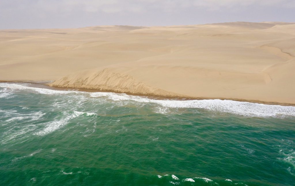
Namibia’s Atlantic coast runs roughly 1,570 kilometres from the Orange River to the Kunene, and almost every metre of it is protected inside a chain of national parks. The cold Benguela current keeps it fogbound and chilly year round while the interior bakes. Four towns and one hamlet sit along it, and the rest is desert meeting ocean.
The Coastal Parks and How the Protection Chain Works
Nearly the entire Namibian shoreline sits inside a protected area, which is unusual anywhere in the world and worth knowing because it determines where you can drive, camp and fish.
Running north to south, Skeleton Coast National Park covers the shore from the Kunene down to the Ugab River. Dorob National Park picks up from the Ugab and runs about 350 kilometres south to the Kuiseb Delta below Walvis Bay, covering some 7,800 square kilometres. Namib-Naukluft National Park takes over from there, and Tsau Khaeb, the former diamond restricted zone, covers the far south towards the Orange River.
Dorob was created out of the older National West Coast Recreation Area chiefly to control off road driving, which had been damaging lichen fields and tern breeding grounds. It includes the Walvis Bay lagoon, a Ramsar listed wetland, while excluding the municipal areas of Walvis Bay, Swakopmund, Henties Bay and Wlotzkasbaken.
Skeleton Coast National Park. Ugab River north to the Kunene. Permit required, strict gate times, and the northern section restricted to fly in guests and concession operators.
Dorob National Park. Ugab south to the Kuiseb Delta. Holds Cape Cross, the lichen fields, Henties Bay and Wlotzkasbaken. Beach driving and angling regulated throughout.
Namib-Naukluft coastal section. South of the Kuiseb, including Sandwich Harbour where the dune sea meets the sea. Permits needed and guided access for the harbour itself.
Tsau Khaeb. The former Sperrgebiet in the far south around Lüderitz. Largely closed, with guided access only to Bogenfels, Pomona and Elizabeth Bay.
Why the Benguela Current Shapes Everything Here
The single fact that explains this coastline is the cold water running up it from the south. The Benguela current keeps sea temperatures low year round, which does three things at once.
It generates fog. Warm air over cold water condenses, and the fog rolls inland most nights and often does not clear until late morning. That fog is the only reliable moisture in a place with almost no rain, and an entire ecology runs on it, from the lichen fields to the beetles that stand on dune crests at dawn collecting condensation on their backs.
It keeps the air cold. Henties Bay sees daytime highs around 18 degrees in August while Etosha bakes, which is why Namibian families holiday here in midsummer and why visitors arriving from the interior reach for jackets within an hour of the coast.
And it makes the water enormously productive. Nutrient rich upwelling feeds the fish that feed the Cape fur seals, the seabird colonies and the commercial fishery at Walvis Bay, and it is why the oysters here grow faster than almost anywhere.
Coastal Towns and Where to Base Yourself
There are only four settlements of any size on 1,570 kilometres of coast, which tells you something about the place.
Swakopmund is the holiday town and the adventure capital, with German colonial architecture, the best restaurants on any Namibian route and every dune sport in the country. Walvis Bay, 30 kilometres south, is the working port built around a Ramsar listed lagoon holding tens of thousands of flamingos and the Pelican Point seal colony.
Henties Bay lies 70 kilometres north of Swakopmund and exists almost entirely for shore angling, with a scatter of holiday houses, a caravan park and a strong fishing club culture. Wlotzkasbaken between the two is stranger still: a hamlet of brightly painted holiday shacks with fewer than a dozen permanent residents, founded as an angling spot and now sitting inside Dorob with its water delivered by tanker.
Lüderitz sits far to the south, cut off from the rest by hundreds of kilometres of restricted diamond ground, and it is reached from the interior rather than along the coast.
You cannot drive the length of this coast. The road runs from Walvis Bay north to the Ugab gate and then only through Skeleton Coast National Park under permit as far as Terrace Bay, where independent travel stops. Lüderitz in the south is reached inland via Aus. Anyone planning a continuous coastal drive should redraw the route now.
Fishing Tours and Angling Along the Coast
Shore angling is the reason a large share of domestic visitors come here, and it has its own culture. Kabeljou, steenbras and galjoen are the prized species, with copper shark, cow shark, spotted gully shark and blacktail also caught from the beach.
A permit is required for all recreational fishing and can be obtained from Ministry of Fisheries offices in Windhoek, Swakopmund, Walvis Bay and Lüderitz, and from the police station at Henties Bay. Angling is permitted from Terrace Bay to Torra Bay in the Skeleton Coast park, from the Ugab River to Walvis Bay in Dorob, from Pelican Point to Sandwich Harbour and in the far south.
Bait rules exist and are enforced: worms may not be used, and only red bait washed ashore may be collected rather than prised off rocks. Competitions run over the December holidays and the coast fills accordingly.
Guided trips are widely available from Swakopmund and Henties Bay and supply rods, bait and the local knowledge of which stretch is producing, which matters more than tackle on a shore this long.
Seal Colonies, Seabirds and Marine Wildlife
Cape fur seals are the animal you will certainly see. Cape Cross in Dorob holds one of the largest colonies anywhere, tens of thousands of animals depending on season, with a boardwalk and a smell that nobody adequately warns you about. Pelican Point at Walvis Bay holds another, reached by boat or kayak.
Heaviside’s dolphins are endemic to this coast and come to boats regularly, alongside bottlenose. Mola mola sunfish and leatherback turtles are recorded. Whales are seasonal and occasional rather than dependable, so treat a sighting as a bonus.
Birdlife is concentrated at the wetlands. The Walvis Bay lagoon and salt works hold tens of thousands of wetland birds, with flamingo numbers reaching into the tens of thousands and over 150 species recorded. The Damara tern, endangered and largely confined to this coast, breeds on the gravel flats, which is precisely why several areas are closed to vehicles.
Brown hyena and black backed jackal work the shoreline scavenging seal carcasses, mostly at night and mostly in the less visited northern stretches.
Lichen Fields and the Fog Ecology
The grey and orange crusts across the gravel plains north of Wlotzkasbaken and Cape Cross are alive. More than a hundred lichen species have been recorded in the Namib, each a partnership between an alga and a fungus, and they survive entirely on coastal fog.
Pour a little water on a dry lichen field and it changes colour and unfurls within minutes, which guides demonstrate on tours. They grow extremely slowly and a single set of vehicle tracks through them stays visible for decades.
That is the reason for the driving restrictions across Dorob and the reason it was proclaimed a national park in the first place. Stay on marked tracks, do not cut across the plains for a photograph, and treat what looks like bare gravel as a living surface.
Driving Rules and Beach Access on the Coast
Off road driving is regulated across the whole coastal strip and the rules catch out visitors who assume an empty beach is open ground.
Driving on the beaches at Henties Bay, Wlotzkasbaken, Swakopmund, Cape Cross and at several of the mile campsites is prohibited. East of the C34 salt road, self drivers are limited to designated 4×4 tracks, with detailed maps available from the Henties Bay tourism office. Vehicles are not permitted inside Dorob between nine at night and five in the morning except on proclaimed roads. Damara tern breeding areas, the Swakop River and the lichen fields are closed entirely.
The salt roads themselves drive beautifully when dry and become genuinely slippery in fog, which is a daily occurrence. Slow down, use headlights, and leave more distance than the empty road suggests.
Best Time to Visit the Namibian Coast
The coast runs on its own calendar, which is the most useful thing to know about it. While the interior passes 40 degrees between November and February, this shoreline stays mild, and that makes it the refuge in the hottest months rather than a summer destination to avoid.
December and January bring Namibian and South African families in numbers, along with the main angling competitions, so towns are full and rates rise. May to September is settled, cool and quiet, and lines up with the main inland safari season.
Fog and wind are the daily variables in every month. Mornings are usually fogbound and afternoons usually windy, which affects boat trips, flights and dune activities. Book those for the middle of the day and keep a spare slot if one activity matters.
Getting to the Namibian Coast
From Windhoek the B2 runs 360 kilometres west to Swakopmund through Okahandja, Karibib and Usakos, four to four and a half hours on tar. Walvis Bay is 30 kilometres further south.
From Sesriem the C14 crosses the Gaub and Kuiseb passes, 340 to 350 kilometres taking five to six and a half hours on mostly gravel. From Damaraland the route comes down through Uis or the Ugab area.
Walvis Bay Airport handles scheduled flights from Windhoek and a small number of regional services, which suits trips starting on the coast and removes the drive. Charter flights link the coastal towns to Sossusvlei, Damaraland and the Skeleton Coast concessions.
Namibian Coast Travel Questions
Can you swim on the Namibian coast?
You can, and very few people do for long. The Benguela current keeps water temperatures low year round, so swimming is bracing rather than pleasant, and currents along this shore are strong. The beaches are for walking, fishing and looking at rather than bathing. Several hotels in Swakopmund and Walvis Bay have pools if swimming is the point of the day.
How much of the coast can I actually drive?
Less than the map suggests. The C34 salt road runs north from Swakopmund past Henties Bay and Cape Cross to the Ugab gate. Inside Skeleton Coast National Park you can continue under permit as far as Terrace Bay, and everything north of there is closed to independent travel. Lüderitz in the far south is unreachable along the coast and is approached inland via Aus, since the diamond area blocks the route.
Do I need a permit for the coast?
For the towns and the C34 salt road, no. Skeleton Coast National Park requires a permit obtained at the Ugabmund or Springbokwasser gates. Sandwich Harbour and the Welwitschia Drive need permits arranged in advance from Ministry offices in Swakopmund or Windhoek rather than at a gate. Recreational fishing anywhere on the coast needs a separate permit, available from Ministry of Fisheries offices and the police at Henties Bay.
Where should I base myself on the coast?
Swakopmund for almost everyone, since it has the accommodation, the restaurants and the activities, with Walvis Bay half an hour south for the lagoon and boat trips. Henties Bay suits anglers above all and is quiet otherwise. Lüderitz is a separate trip in the far south rather than part of the same coastal stay.
Why is the Namibian coast so cold and foggy?
The Benguela current carries cold water north along the shore. Warm air passing over it condenses into fog that rolls inland most nights and often lingers until late morning. The same cold water keeps daytime air temperatures far below the interior, so the coast can sit near 18 degrees while Etosha is above 35. That fog is also the only dependable moisture here and supports the lichen fields and much of the desert wildlife.
Is beach driving allowed?
Only in limited places and on marked tracks. It is prohibited at Henties Bay, Wlotzkasbaken, Swakopmund, Cape Cross and several campsites, and east of the C34 you are restricted to designated 4×4 routes. Lichen fields, Damara tern breeding grounds and the Swakop River are closed entirely. Maps of permitted tracks are available from the Henties Bay tourism office, and the restrictions exist because tyre damage here lasts for decades.
How many days should I spend on the coast?
Two to three nights based in Swakopmund covers the towns, a Walvis Bay boat trip and a dune or desert activity comfortably. Add a day for Sandwich Harbour or a run north to Cape Cross. Anglers and anyone heading into Skeleton Coast National Park should allow more. The coast also works well as the rest point in the middle of a longer Namibian road trip.
Booking Your Namibia Trip
The safari companies and tour operators listed on this website put trips like this together for a living and know which camps, guides and routes actually deliver. We are an independent guide to Namibia; we do not book or sell tours ourselves.
When you are ready, arrange your safari, tour or holiday with one of the recognised operators listed here. Tell them your dates and what matters most, and a real person, not a form, will handle the itinerary, park bookings and logistics for you.