Skeleton Coast Shipwrecks
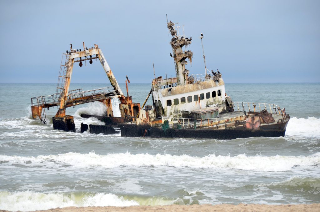
Hundreds of vessels lie along the Skeleton Coast, wrecked by fog, offshore rocks and a current that pushes ships onto a shore with no harbour for a thousand kilometres. The Eduard Bohlen now sits 800 metres inland as the desert has advanced past it. The Zeila near Henties Bay is the one you can reach in an ordinary car.
Why So Many Ships Wrecked Here
The Skeleton Coast is one of the most dangerous shorelines in the world and the reasons compound one another.
Dense fog forms most nights where the cold Benguela current meets warm desert air, and it sits over the water until late morning. Offshore rocks and shifting sandbanks lie unmarked. The current pushes north and inshore, so a vessel losing power drifts towards land rather than away from it.
What made it lethal was the absence of anywhere to go. There is no natural harbour along most of this coast, no fresh water, no settlement and, historically, no help. A crew that survived the wreck came ashore into desert.
The name itself comes from the whale and seal bones that littered the shore from the whaling years, and it stuck because ships’ skeletons joined them. It was coined by John Henry Marsh as the title of his book about the Dunedin Star rescue, published in the nineteen forties, and the name has been on maps ever since.
The Eduard Bohlen
The Eduard Bohlen is the most photographed wreck in Namibia and the one that best explains what this coast does.
A 2,272 ton German passenger and cargo ship of the Woermann Line, 95 metres long, she was running from Swakopmund to Table Bay when thick fog put her aground at Conception Bay in September 1909.
She wrecked on the shoreline. She now lies roughly 800 metres inland, half buried in sand, with dunes on all sides and the sea a distant line. The desert has advanced past her over a century, which is the detail that makes the photographs so strange: a substantial ocean going vessel sitting in sand with no water anywhere near it.
She is not reachable by road. The wreck sits inside the restricted diamond area of the central Namib, and the way to see her is from the air.
Book a scenic flight between Swakopmund and Sossusvlei routed via Conception Bay if the Eduard Bohlen matters to you. That single leg passes over both the Bohlen and the Shawnee, and it turns a transfer you may be making anyway into the only practical way of seeing the coast’s best wrecks. Booking a dedicated flight costs considerably more for the same view.
The Dunedin Star and the Rescue
The Dunedin Star produced the most elaborate rescue operation ever mounted on this coast and it is the story the coast is named for.
A British cargo and passenger liner carrying ammunition and supplies for the British army in North Africa, running from Liverpool to Egypt via Cape Town, she struck a reef and grounded south of the Kunene River mouth in November 1942, with 85 crew and 21 passengers aboard.
Sixty three people, including eight women and three babies, were brought ashore by motorboat before heavy swell disabled it, leaving 43 aboard a breaking ship and the rest stranded on an empty beach.
What followed ran until Christmas Eve. A tug and a converted minesweeper went north from Walvis Bay. A land convoy of eleven trucks set out from Windhoek. A Ventura bomber flew from Cape Town to drop supplies, landed on the beach and became stuck in loose sand.
The rescue cost further vessels. The South African steam tug Sir Charles Elliott, which had assisted the operation, ran aground and was destroyed near Rocky Point in December 1942 while heading back to Cape Town.
Everyone from the Dunedin Star survived. Access to the wreck site is limited, in the far north of the coast beyond independent travel.
The Zeila
The Zeila is the accessible one and it is the wreck most visitors actually see.
A fishing trawler sold as scrap to an Indian company, she came loose from her towing line shortly after leaving Walvis Bay and grounded in the early hours of a morning in August 2008, near a fishing spot about 14 kilometres south of Henties Bay.
She sits close inshore, visible from the beach and reachable on a short walk from a parking area off the C34 salt road. No permit is needed and the drive is on good gravel suitable for most vehicles.
Rust has worked on her since, and the hull has been steadily colonised by cormorants, which perch across the superstructure in numbers. That combination of decaying steel and seabirds makes her more photogenic than a newer wreck would be.
Operators travelling between Swakopmund and Damaraland frequently stop here for a beach picnic, which is a reasonable way to work her into a driving day.

Other Wrecks Along the Coast
Hundreds of vessels lie along this shore and a handful are named often enough to be worth knowing.
The Shawnee, wrecked in the nineteen seventies, sits partially buried in sand near Conception Bay and is best viewed from the air alongside the Bohlen.
The Otavi, the Benguela Eagle and the Tong Taw appear on wreck lists along the coast. The Erycina went down north of Cape Cross in 1896 carrying a load of guano bound for the United Kingdom, and old photographs show her stern under water with masts still standing.
The Natal Coast, a First World War era cargo ship, grounded in heavy fog around 30 kilometres north of Swakopmund in 1955 carrying over 3,000 tons of cargo including a substantial load of coconuts, then rare here. A scrap merchant later took her apart and only parts of the boilers and engine room show at low tide.
The oldest wreck in the region is a different matter entirely. The Bom Jesus, a Portuguese vessel from the fifteen hundreds, was found near Oranjemund in the diamond area and recovered by international archaeologists over nearly two years.
Identifying What You Are Looking At
A word of caution about wreck identification on this coast.
Salt, wind and sand destroy steel quickly here, and a vessel that grounded decades ago may be reduced to unrecognisable fragments. Wrecks also move, break up and become buried and re-exposed as the sand shifts.
The consequence is that some wrecks named confidently in guidebooks and on signage are misidentified, and that lists of wrecks vary considerably between sources. Photographs circulating online are frequently attributed to the wrong vessel.
Preservation is limited by the environment and the remoteness. Ongoing work focuses on documentation and public awareness rather than restoration, which in these conditions would be close to impossible.
If accurate identification matters to you, go with a guide who knows the specific wrecks rather than relying on a signpost.
How to See the Wrecks
Zeila by road. About 14 kilometres south of Henties Bay off the C34, a short walk from a parking area. Good gravel, no permit, any vehicle. The easiest wreck on the coast.
Eduard Bohlen and Shawnee by air. Scenic flights from Swakopmund or Walvis Bay, or a transfer leg to Sossusvlei routed via Conception Bay. The only practical way to see either.
North of the Ugab gate. Permit required, day permits available at the gate. Overnight only with a lodge booking. Self drive reaches Terrace Bay and no further.
The far north. Concession area only, reached by fly in with licensed operators. No private driving. This is where the Dunedin Star site lies.
Permits and Restrictions
Access rules along this coast are stricter than most visitors expect and they vary by section.
The stretch from Swakopmund north past Henties Bay and Cape Cross to the Ugab River sits in Dorob National Park and needs no special permit. This is where the Zeila is.
Beyond the Ugab gate you are in Skeleton Coast National Park and a permit is required. Day permits are available at the gate, overnight stays only with a lodge booking, and self drivers can go no further north than Terrace Bay.
Everything north of Terrace Bay is a concession wilderness area accessible only through licensed operators and fly in camps. There is no permit an independent traveller can buy.
The central Namib coast south of Walvis Bay, where the Bohlen lies, is restricted diamond area. Sandwich Harbour is reachable with a permit and a guide; Conception Bay is not.
Best Time to See the Shipwrecks
May to October gives cool dry weather and the best light for photography, with July to September bringing the lowest fog density.
Fog is the practical variable in any month. Mornings on this coast are frequently fogbound and usually clear by late morning, which affects both scenic flights and photography. Flights are cancelled for fog and wind regularly.
For the Zeila, low tide exposes more of the hull and the surrounding wreckage. Late afternoon light works better than midday, and the rusted steel takes colour well when the sun is low.
Book scenic flights early in your coastal stay so there is room to reschedule if conditions cancel one.
Skeleton Coast Shipwreck Questions
Which shipwreck can I reach by car?
The Zeila, a fishing trawler that grounded in 2008 about 14 kilometres south of Henties Bay. It sits close inshore, visible from the beach and a short walk from a parking area off the C34 salt road, on good gravel suitable for most vehicles with no permit required. It is comfortably the most accessible wreck on the coast and the one most visitors see.
Why is the Eduard Bohlen inland?
Because the desert moved. She grounded on the shoreline at Conception Bay in fog in 1909, and over more than a century the coast has advanced seaward past her. She now lies roughly 800 metres inland, half buried in sand with dunes around her and the sea a distant line. It is the single strangest sight on this coast and the reason she is the most photographed wreck in Namibia.
How do I see the Eduard Bohlen?
From the air. She sits inside the restricted diamond area of the central Namib and is not reachable by road. Scenic flights run from Swakopmund and Walvis Bay, and a transfer leg between Swakopmund and Sossusvlei routed via Conception Bay passes over both the Bohlen and the Shawnee, which is the cheapest way to see them if you are making that flight anyway.
What happened to the Dunedin Star?
A British liner carrying supplies for the army in North Africa, she struck a reef south of the Kunene mouth in November 1942 with 106 people aboard. Sixty three reached shore by motorboat before swell disabled it. The rescue ran until Christmas Eve involving a tug, a minesweeper, eleven trucks from Windhoek and a bomber that landed on the beach and became stuck. Everyone survived, and a rescue tug was itself wrecked.
Why did so many ships wreck here?
Dense night fog forms where the cold Benguela current meets warm desert air and sits until late morning. Offshore rocks and shifting sandbanks lie unmarked. The current pushes north and inshore, so a vessel losing power drifts towards land. And there is no natural harbour, no fresh water and no settlement along most of the coast, so surviving the wreck meant coming ashore into desert.
Do I need a permit to see the wrecks?
Not for the Zeila or anything south of the Ugab River, which sits in Dorob National Park. Beyond the Ugab gate you need a Skeleton Coast permit, available at the gate for day visits, with overnight stays only through a lodge booking and self drive going no further than Terrace Bay. North of that is concession area reachable only with licensed fly in operators.
Are the wrecks correctly identified?
Not always. Salt, wind and sand destroy steel quickly, wrecks break up and become buried and re-exposed as sand shifts, and some vessels named confidently on signage and in guidebooks are misidentified. Photographs circulating online are frequently attributed to the wrong ship. If accurate identification matters, go with a guide who knows the specific wrecks.
Booking Your Namibia Trip
The safari companies and tour operators listed on this website put trips like this together for a living and know which camps, guides and routes actually deliver. We are an independent guide to Namibia; we do not book or sell tours ourselves.
When you are ready, arrange your safari, tour or holiday with one of the recognised operators listed here. Tell them your dates and what matters most, and a real person, not a form, will handle the itinerary, park bookings and logistics for you.